GIS – Data Development Course
GIS – Data Development Course
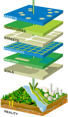
Enables the learner to create, use and manage spatial data used in developing Maps and Apps
| GIS Data Development Course | 19th June | 8:00 am & 5:00 pm |
| GIS Application Development Course | 19th June | 7:30 am & 5:30 pm |
| Android Application Development Course | 15th June | 7:30 am & 5:30 pm |
Course Introduction
This course provides an overview of the theoretical and practical foundations of the applied use of Geographic Information Systems (GIS). At the end of the course, you will have a working knowledge of GIS and how to apply these systems in various situations and organizational settings.
This course will introduce you to the design and development of basic GIS applications and systems. Utilizing knowledge gained in core GIS courses; you will develop the fundamental components of a GIS solution.
This course teaches what a GIS is and what you can do with it. Working with various components of the GIS system, you will create GIS maps, explore and analyze the data behind the maps, and apply methods to analyze your maps.
By the end of the course, you will have a solid understanding of how GIS maps and GIS tools are used to visualize real-world features, discover patterns, obtain information, and communicate that information to others.
Geosys has designed “GIS – Data Development Course” for people with an interest in the use of applications of geospatial technologies (GIS, remote sensing) to environmental and social change issues.
Geosys Trainees will learn not only the tools of spatial analysis, but also will learn how to apply these tools to real life problems in the course of seeking solutions. The course of study is designed to accommodate both GIS novices and people with previous GIS experience.
GIS Data Development Course (GIS-DDC) Placement-Cum-Training Program:
Level |
Topic Names |
Mapping Essentials |
|
GIS Essentials |
|
Foundation |
Data Sources for GIS |
Introduction to Web GIS Platform |
|
Components of Desktop GIS |
|
Display Feature and Tabular data |
|
Work with Georeferenced Spatial Data |
|
Basic |
Querying Features using Logical Expressions |
Find Features using Spatial Relationships |
|
Editing spatial data -Creating Features |
|
Edit attribute data - Creating a Base Map |
|
Integrating CAD Data with GIS |
|
Intermediate |
Associate Tables with Joins and Relates |
Produce Maps, Reports, and Graphs |
|
Manage Geographic data |
|
Perform Geocoding |
|
Automated Vectorization |
|
Advanced |
Creating Vector Data on Google Earth |
Convert data from other formats |
|
Parcel Editing |
|
Perform spatial analysis |
|
Create and Use Metadata |
|
Implementation |
Real time Project |
Getting Started with Web GIS |
DDC Training GOAL
Geosys GIS training programs aims to give a strong theoretical foundation and excellent hands-on skills to prepare participants explore careers in and meet the challenges of the GIS world- Find, explore, and create maps using GIS.
- Help students visualize and query the spatial data and attribute data and make connections to their own environment.
- Present questions and have students explore GIS maps to find answers.
- Guide students through a standard process for investigating a problem using GIS.
- Prepare a GIS map presentation on a topic of interest.
- Prepare a Layout of the map for the AOI.
- Connecting to geospatial data over the internet.
- Working with geodatabase.
- How to work with attribute data.
- Displaying, symbolizing and classifying geospatial datasets.
- Creating maps for printing.
- How to perform attribute and spatial data queries.
- How to perform spatial analyses.
- On-screen digitizing of map data; importing coordinates.
- Metadata - what it is and why you need to know about it and create it.
After successfully completing this course, you will have acquired an understanding of general GIS terms and the basic functionality of GIS software suite.
- Quickly create and Edit a GIS Map.
- Find and organize geographic data and other GIS resourses for a mapping project.
- Accurately display features on a GIS map and efficiently access information about them.
- Analyze a GIS map to identify where features that meet specific criteria are located.
- Create GIS maps and analyze results so they can be viewed using desktop applications.
Course Overview
- Explore conceptual foundations of spatial information systems.
- Review cartographic and data visualization techniques.
- Examine several types of geospatial data and spatial information systems.
- Address the needs of the Spatial Analysis of the maps.
- What is the GIS System?
- GIS Basics
- What are the essentials of GIS?
- Mapping real-world feature locations using coordinate systems.
- Finding GIS maps and data
- Exploring a GIS maps.
- GIS analysis
- Create Map Layout.
Pre-requisites
Q. What is the pre-requisite to take GIS - DDC Training?- Any person with passion and who wants a career in GIS can opt for GIS-DDC Course.
- Minimum Computer Knowledge with any qualification.
- Should be a graduate.
- A fresher, who is looking to make his career in GIS analysis.
- An Experienced Professional who wishes to switch over to GIS Development.
- Any GIS Professional who wishes to improve his/her skills.
Desired Candidate Profile
- Any Graduate with Good grasping skills.
- Good Communication & Presentation Skills.
- Self-Starter, Problem Solver, Strong Analytical Skills.
FAQs
Q. How much does it cost?A. Our programs are very competitively priced and reflect the level of choice and availability of modules open to you as a Trainee.
Q. Does Geosys offer any Projects?
A. Yes, with every course we have a sample project document along that contains complete source code. We also provide a special course on developing Projects which will help you to learn the process involved in all the stages of data development and application development.
Q. What is the pre-requisite to take GIS - DDC Training?
A. Any person with passion and who wants a career in GIS can opt for GIS-DDC Course.
Q. Can I take a break between modules?
A. We appreciate that you are likely to be balancing study with other commitments such as employment and family and so we will do our best to accommodate any requests you make.
Q. How long does it take to complete the program?
A. We have four programs. The table below illustrates the duration of each course
| Program | Duration | Batch time |
|---|---|---|
| GIS - DDC | 4 weeks | Flexible Timings |
| GIS - ADC | 4 weeks | Flexible Timings |
| Web API’s | 4 weeks | Flexible Timings |
- Be a Part of GIS Data Development Team.
- Understanding Client's Requirements.
- Be a Part of GIS data analysis Team.
- Could be a part Maintenance project/Application support Project.
Q. Who will clarify my doubts, if any?
A. You can post a question to info@geosys.co.in. And we could provide you with the solution.
Testimonials
Posted by : M .Rajasekhar ★★★★★
"I am M .Rajasekhar from CSIR-IICT, I have attended ArcGIS data development course at Geosys. To my knowledge this is the sole institute providing training regarding ArcGIS in Hyderabad. This course helped me to understand the basic concepts of GIS applications. This course is very informative and very helpful for the basic level trainees. The course structure and teaching facilities are very comfortable that a layman can understand the concepts of GIS very easily. One can step out with the good knowledge of GIS application from the course. The practical sessions and the material provided help you to work individually. The assistance by the staff is so encouragable. Thank you."
Posted by : Kiran Chowdary ★★★★★
"Hi, I am Kiran Chowdary. I completed my B.tech in civil engineering from JNTUH, Kukatpally. I am working as a civil engineer in FLORIDA TRANSPORTATION ENGINEERING.INC .As a part of my office training I joined in Geosys for ArcGIS-DDC course.My experience in Geosys is really awesome.Well planned course and well planned delivery of subject helped me in achieving good knowledge to the full extent.Faculty helped me a lot to achieve more knowledge by clarifying all my doubts.I am very thankful to Geosys."
Posted by : Kaleem khan ★★★★★
"Hi I am Kaleem khan having 8 years experience in the Telecom Sector. As if now I did not use the ArcGIS. After coming to Geosys got how to use the ArcGIS well. ArcGIS is very useful in the world the Faculty of Geosys having good experience in teaching from the beginning of the ArcGIS .I got like done live experience from the Geosys lab.I am very glad to have taken classes here in the Geosys."
Posted by : Surendar Raju ★★★★★
"I have undergone 6 days training program in Geo Spatial Technologies at GEOSYS. Training was excellent and was up to the mark of our industry requirements. Faculty is good and having sound knowledge in their domains."
Posted by : Sumit Kumar Mishra ★★★★★
"I have completed my Post Graduation and applied geology in 2016 from Sambalpur University, Odisha. I wanted to work in GIS line and started searching for jobs. Then I came to know about for Geosys and joined here for the training. Here everything is fine among all the staffs and faculty members, including the class and the handouts. I will recommend my juniors and my classmates for this training, which is very useful for our job."